What it takes to find the right land for carbon projects
Every successful forest carbon project starts with a crucial decision: choosing the right land.
Not every plot can deliver the measurable carbon sequestration required to generate high-quality carbon credits. Factors like soil quality, land use history, and existing vegetation all play a crucial role in determining suitability.
The first step is to understand what type of land it is. For example, abandoned land or out-of-production fields are ideal for afforestation. Forest land might be well suited for improved forest management, such as delaying harvesting to enhance carbon storage. And then there are plots that simply aren’t suitable for carbon projects— whether due to extreme weather risk, species vulnerability, or competing land uses.
But how do we guarantee that only suitable plots are selected?
That’s where the Carbon Opportunity Assessment (COA) comes in.
The COA is a report that assesses land suitability, using rigorous standards to ensure that only plots with a clear, positive impact on the carbon balance are included in our projects. It also provides landowners with a clear overview of their land’s carbon income potential.
There are two assessments: empty plots are evaluated for our Afforestation project (planting), while forests are examined for Impact Forestry (delayed harvesting).
For both, the COA can be broken down into three different parts:
- Land suitability analysis
- Plot-specific recommendations
- Carbon credits and income for landowner
Let’s explore each one.
How does the COA assess suitability for carbon projects?
In each country where we run projects, we collect and manage all the necessary data for every step of our land assessments.
This is done within the Geographic Information System (GIS) engine of our COA tool, and includes:
- Informational layers: Soil type, habitat, bonity, land use, and other environmental factors to decide which tree species are most likely to thrive in the long-term
- Practical restrictions: Physical limitations that could prevent us from planting forests in the area, like the presence of water bodies, buildings, drainage channels, powerlines, or landfills
- Legal inputs: Existing regulations from local, national, EU, international or Verra regulation perspectives that might prevent afforestation on certain lands, such as existing registered forest land, protected areas, and organic soils
- Potential limitations: Situations that require additional checks or seek permits for afforestation, such as lands previously used for agricultural drainage
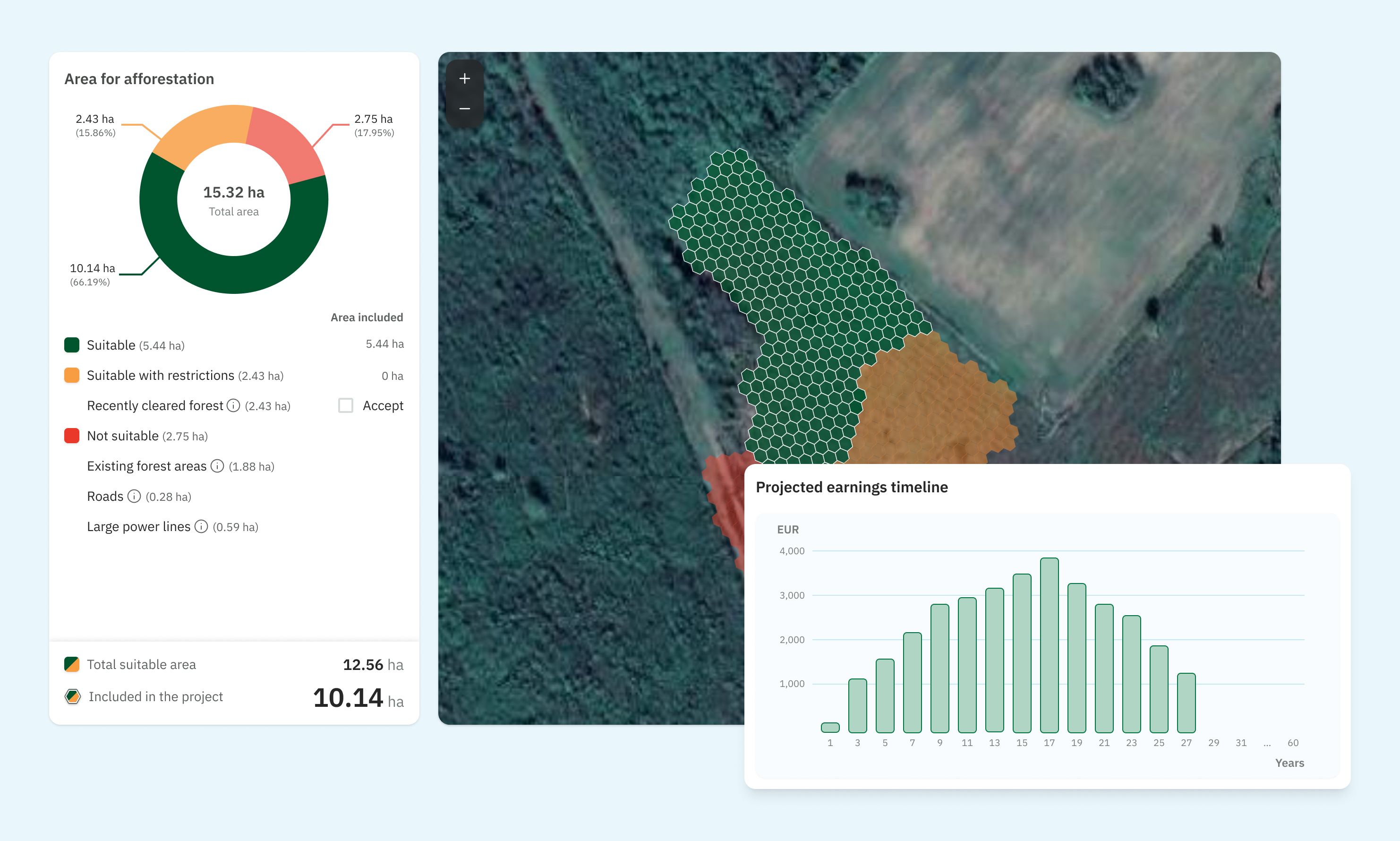 Figure 1: Carbon Opportunity Assessment assessing a forest's suitability for an Afforestation project.
Breaking down the COA: how it works
With multiple variables at play, how do we ensure that our land assessments are always accurate and up to date?
Let’s review our processes:
Source on-ground data from country-specific authorities
Growing and conserving resilient forests is an exact science that requires careful consideration of many factors. This is why we use data from local, country-specific authorities, instead of relying on broad global data sets that lack precision.
For example, while a global soil map might label an area as ‘peaty, wet soil’, the Estonian national soil map provides the exact soil type code for that specific spot. This level of accuracy is key for making informed decisions about forestry projects.
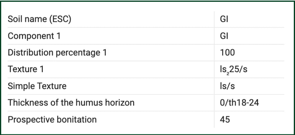 Figure 2: Soil data from the Estonian Soil Map for coordinates XY: 6540205.21, 517090.27 and BL: 59.000464, 24.29737.
Combine data layers where relevant
We combine multiple data sources into a single layer, wherever necessary, to minimise unnecessary layers and redundancies. For example, we integrate both Estonian and EU data for Natura2000 registered areas, providing a detailed and reliable understanding of the land without duplicating efforts.
Update data layers regularly
Constantly evolving information, like cadastral maps or registered forest lands, is updated every three months or sooner if needed. Historical data, such as areas deforested in the last decade, is updated annually. This allows us to continually adjust and refine our project strategies for maximum impact.
Actionable, parcel-specific recommendations
The COA provides landowners with key recommendations and measurable deliverables in an easy-to-understand format.
To do this, we divide a given land area based on habitat types. For our Afforestation project, the tool identifies the best combination of species to plant for each habitat.
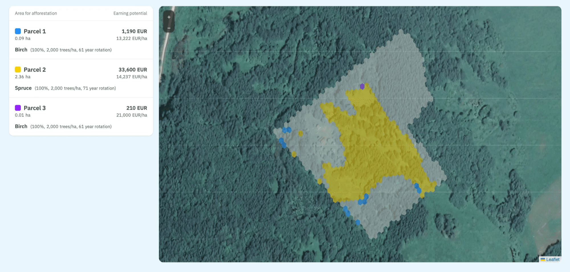 Figure 3: The Carbon Opportunity Assessment analyses each plot of land and determines the best species to plant for each habitat.
For Impact Forestry, the tool identifies the species in each plot, estimates future growth rates, and calculates the carbon income if the forest is left to continue growing.
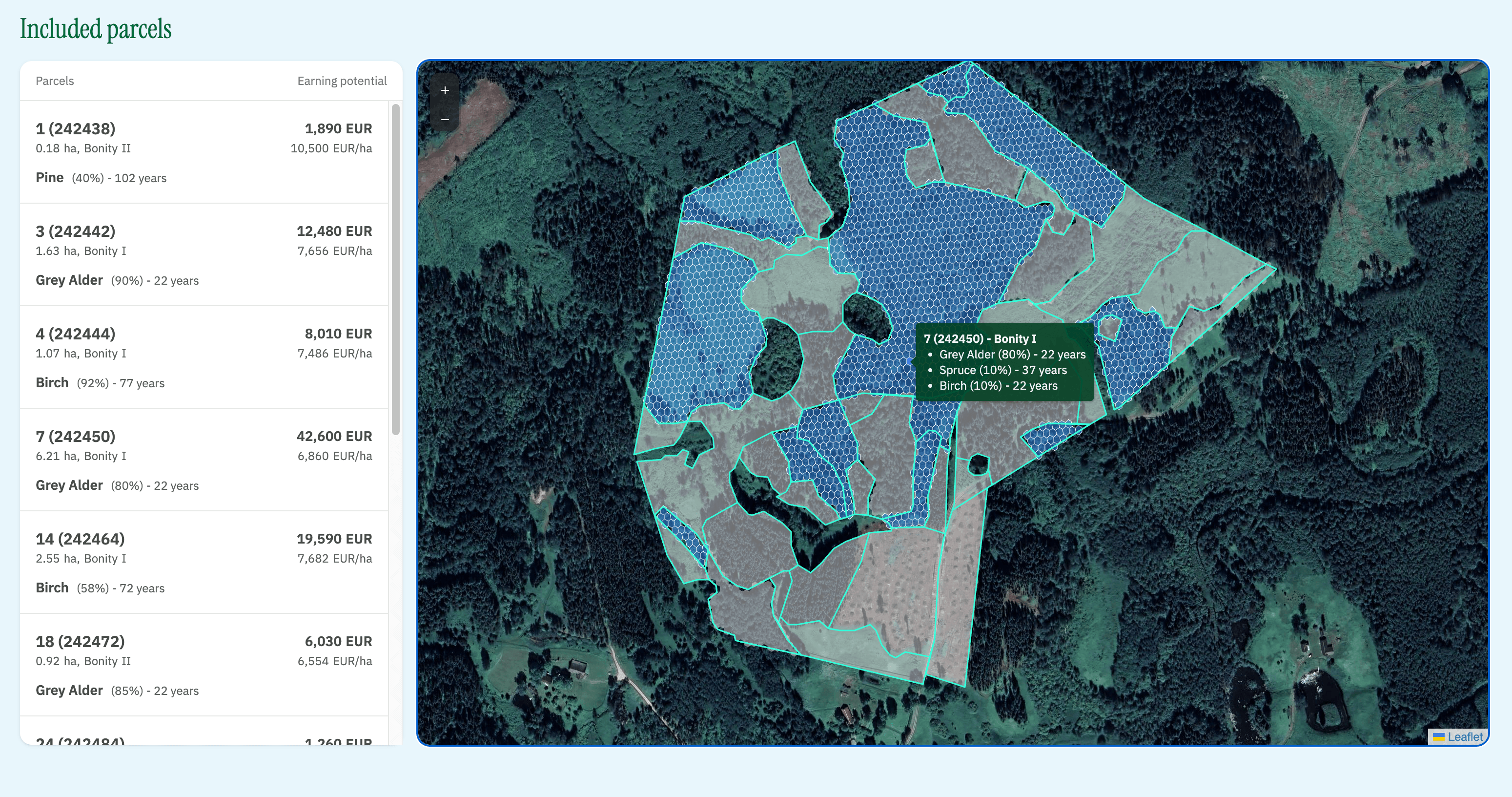 Figure 4: Included parcels analysis in our Carbon Opportunity Assessment for Impact Forestry.
Clear projection of income for landowners
The third and final part of tool calculates the carbon credits and income generated each year over the course of the project. Landowners can clearly visualise their earning potential, helping them make an informed decision about whether to join our project.
If you’re interested in learning more about our technology, just reach out to our team— we’re happy to provide a demo!