The backbone of Arbonics: understanding our technology
Key takeaways:
- Successful carbon removal in forests depends on advanced technology to evaluate, monitor, and guide the project
- We combine over 50 data layers with advanced growth and baseline behaviour models to accurately monitor forest health and demonstrate both the impact of participating in our projects and the alternative scenario without involvement
- Creating a 'digital twin' of each land plot enables detailed, real-time monitoring, allowing us to identify risks early and support landowners in maintaining compliance while maximising carbon sequestration
- Ultimately, this data-driven approach ensures quality and permanence across all of our projects
Climate change remains one of the biggest challenges of our time. Nature-based solutions could provide 30% of the emissions reductions needed to meet the 1.5/2°C target set by the Paris Agreement, but they must be supported by robust data to reach their full potential.
Specifically, for afforestation and improved forest management projects to make an impact at scale, transparency is key. This can only happen when on-ground actions and changes are effectively tracked with data.
This is where the right technology plays a crucial role. Delivering high-quality projects cannot happen without the ability to rigorously assess and monitor the carbon sequestration and biodiversity of forests.
What does it mean to drive quality? Some of the key criteria include:
- Accurately identifying land that fulfils the regulatory, legal and geological frameworks
- Closely monitoring and guiding landowners’ forest management activities
- Leveraging remote sensing or built-in warning systems to identify risk or non-compliant behaviour as early as possible
Let’s explore our proprietary technology in detail.
Prefer to watch instead? Our co-founder Lisett walks you through the details in this video.
Bridging critical gaps in the voluntary carbon market
As a multi-disciplinary team of scientists, forestry experts, and engineers, we have closely observed the evolution of the voluntary carbon market over the years. As a result, we are acutely aware of the current gaps in solutions that prevent effective carbon removal.
So, when the time came to design our proprietary platform, we combined our collective learnings to develop a technological solution that bridges these existing gaps in the market:
Localised data for high accuracy
Today, most players in the market rely on broad datasets to assess climate mitigation potential. Although such data points provide global coverage, they are inherently vague and less precise.
Accurate monitoring of forests' health can only happen with reliable data. As such, our technology takes a local approach, utilising on-ground data directly from trusted registered authorities in our core markets. This gives us accurate assessments of soil, habitats, current species and land quality for each region. Thanks to this customised approach, we understand the role of land in each specific location, ensuring higher accuracy in our projects.
Digital twin approach
As soon as a landowner partners with us, we create a ‘digital twin’ of their land. This involves breaking down the entire land area into smaller hexes, which are then mapped for over 50 underlying data layers.
This enables a high level of granularity when we check, plan, measure and monitor each variable at any given time, not just at the project’s beginning.
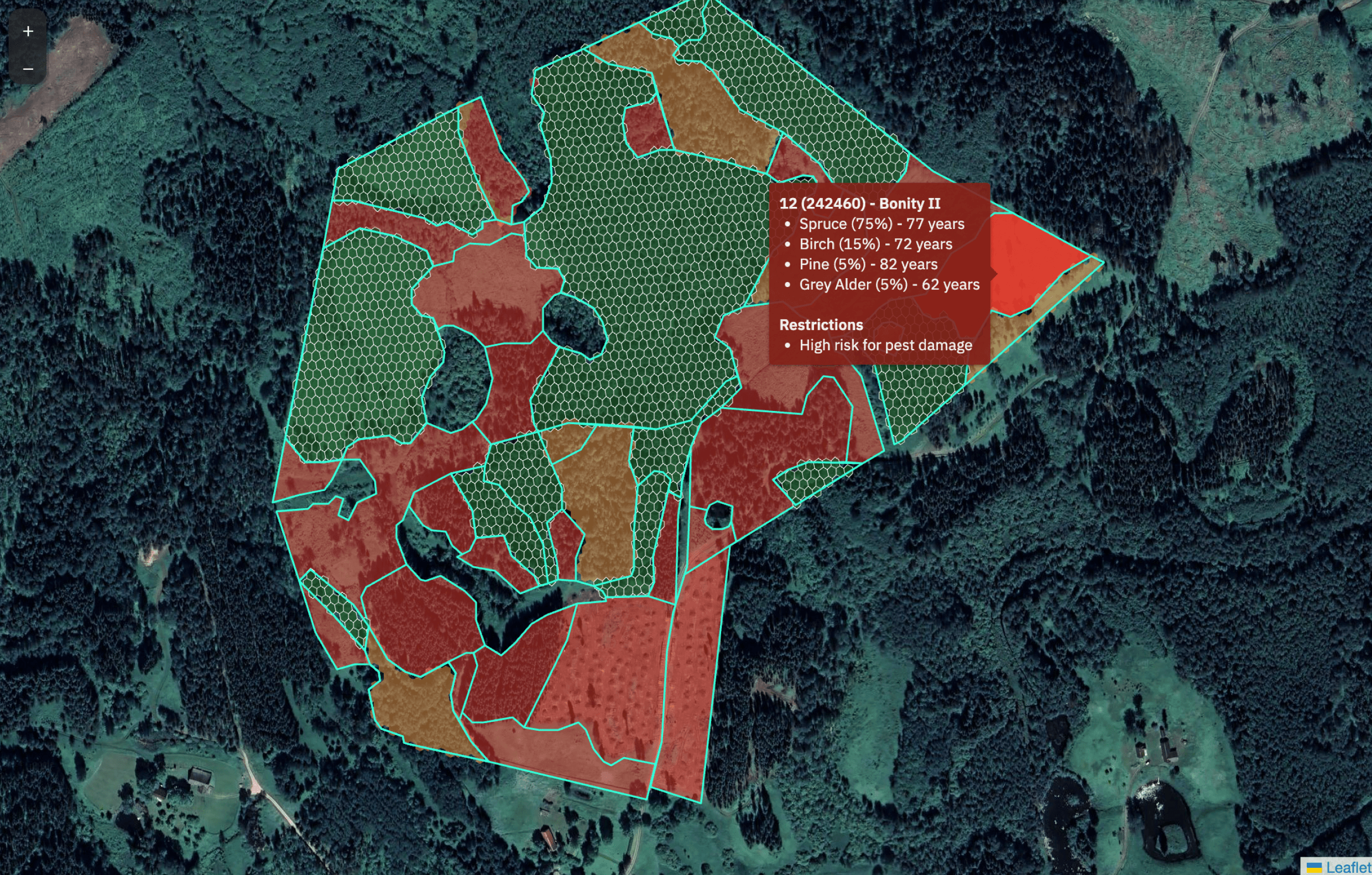 Figure 1: Arbonics’ digital twin technology
Accessible user platform
Our technology is not only designed for forestry experts, it is made for everyone. Its intuitive interface simplifies the complex world of carbon science and makes it accessible to all stakeholders involved.
Landowners can visualise the carbon sequestration potential of each plot of their land, while carbon buyers see the real-world impact of their investments.
Root: our system’s central repository
Every scalable solution starts with a strong foundation. For us, that’s ‘Root’. As the central database of our platform, it securely stores all our data and core functionalities in one place.
Our data sources range from geo-informatics databases to local government authorities and external systems like Kanop. As the central repository of these sources, Root plays a crucial role in integrating this diverse data into a unified system. This eliminates redundant silos, ensures the highest data accuracy, enhanced security, and allows our systems to access a seamless flow of information as and when required.
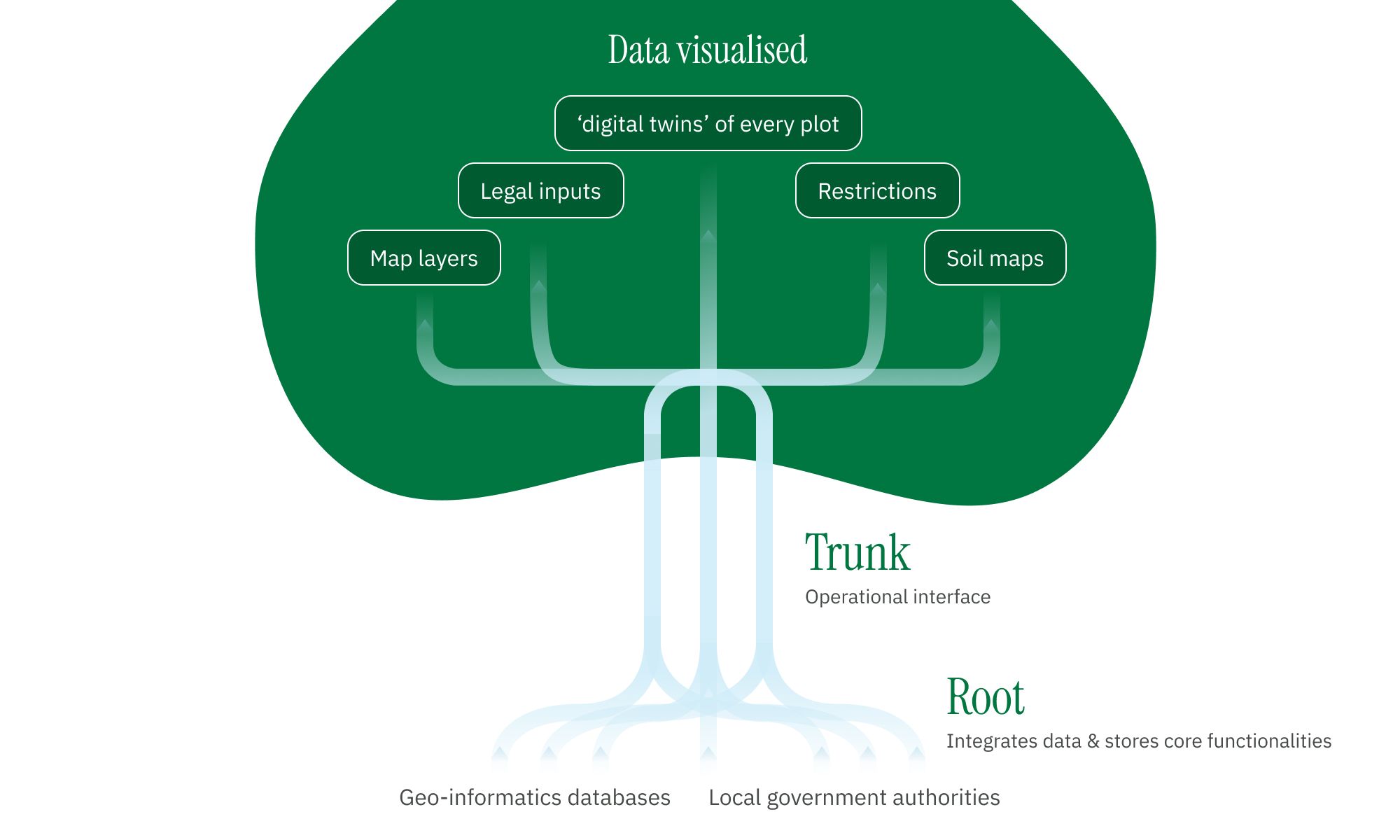 Figure 2: Root is the central repository of our data sources.
Trunk: an operational control powerhouse
‘Trunk’ is the hub for all the crucial operations in our projects. Our internal teams leverage this platform to assess any plot of land for its carbon removal and biodiversity potential, ensuring we only partner with the right landowners. It also helps us manage all our Afforestation and Impact Forestry projects, and monitors progress across tens of thousands of hectares of land from a single central portal.
Aside from offering an accessible dashboard and reporting, Trunk allows us to perform a variety of daily and unique functions, such as managing our portfolio, forecasting the future issuance of carbon credits, and responding to customer queries.
It is also where we store the ‘digital twin’ of every plot in our projects and where we monitor the 50+ data layers pertaining to each plot. It manages everything behind the scenes for our successful carbon project, and delivers transparent, data-backed insights to our partners, ensuring both buyers and landowners have access to reliable information.
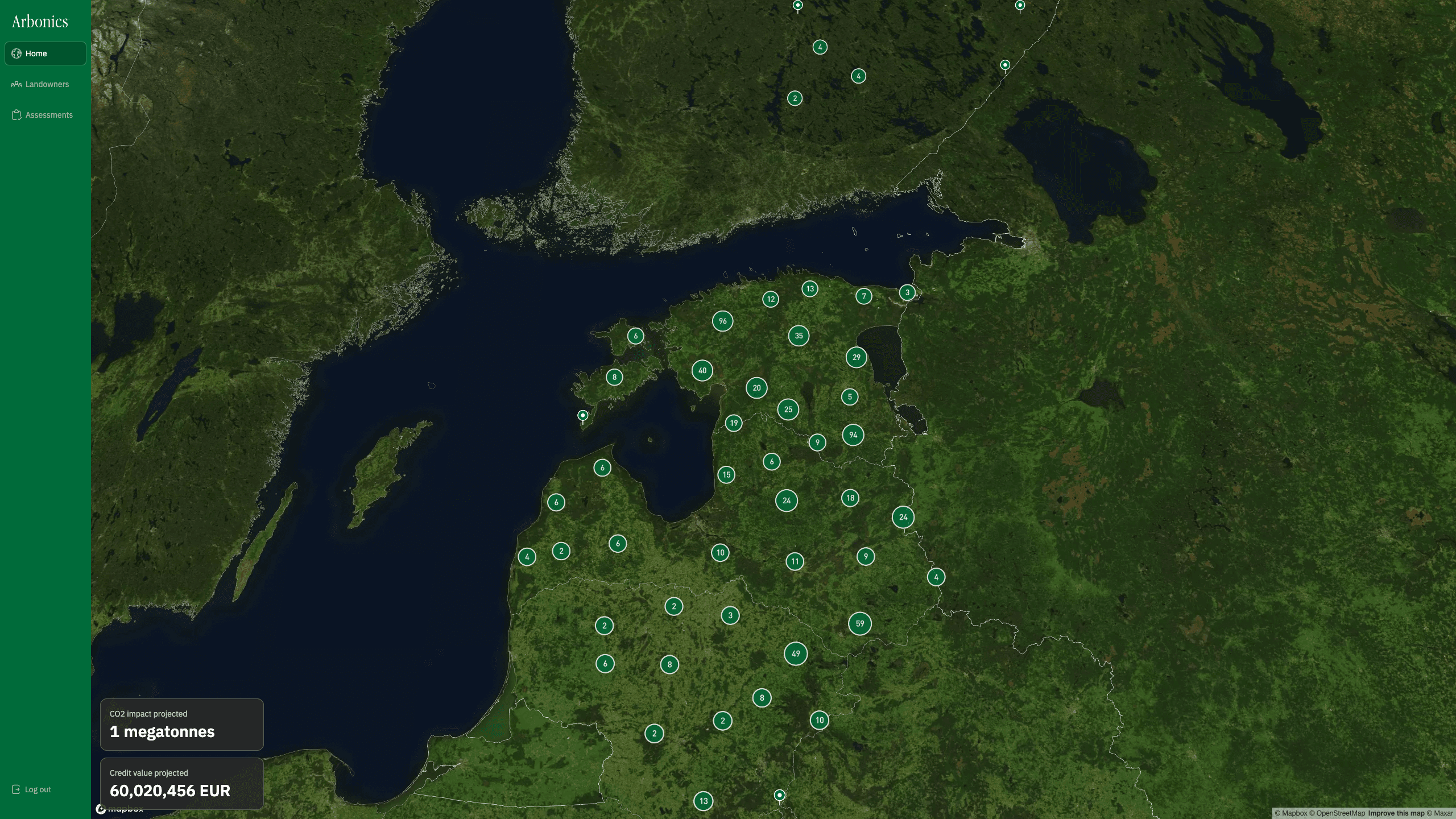 Figure 3: Trunk interface
Carbon Opportunity Assessment
The Carbon Opportunity Assessment (COA) is a report for landowners that assesses both empty plots and mature forests for their environmental and economic potential. There are two assessments: one designed for our Afforestation projects (planting) and another tailored to Impact Forestry (delayed harvesting). Powered by Root and accessed through Trunk, the COA provides clear insights— for afforestation, for example, it shows exactly where they can plant, where planting is possible under specific terms to qualify for carbon project, and what they should plant to maximise the carbon impact of their land.
Here’s a quick overview of the COA’s key features:
- Combines 50+ data layers with advanced growth models to assess the specific areas that are suitable for a project
- This approach models both the impact of joining our projects and the outcome without participation, offering a clear view of the actual impact.
- Gives landowners clear, on-ground data, such as a timeline of projected carbon earnings
- Evaluates any risks and restrictions on the land, like pest damage or existing nature preservation programs
- For Impact Forestry, it anticipates growth trends for the tree species on site to ensure they will continue thriving for the 40-year duration of the project
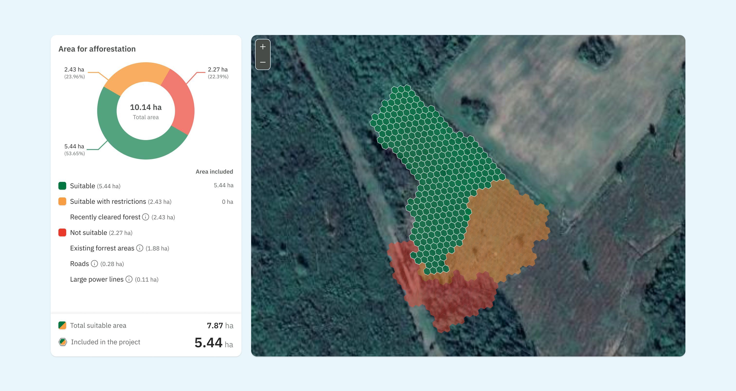 Figure 4: Carbon Opportunity Assessment assessing a forest's suitability for our Afforestation project.
To provide landowners with tailored recommendations, we divide a given land area based on habitat types. Then, the tool identifies the best combination of species to plant for each habitat. It also calculates the carbon capture and credits generated each year over the course of the project. This information is presented in a concise, actionable report to the end users.
Coming soon: the landowner Branch
We are proud that our technology is operating in four countries across the EU, helping hundreds of landowners earn a steady income from their forests. In 2025, we will introduce the ‘Landowner Branch’ to our core platform. This new portal will allow landowners to easily assess their land’s potential, manage plots, and track credit issuance and sales. This forms part of our continuous effort to simplify complex forest data, and make carbon markets more accessible for everyone involved.
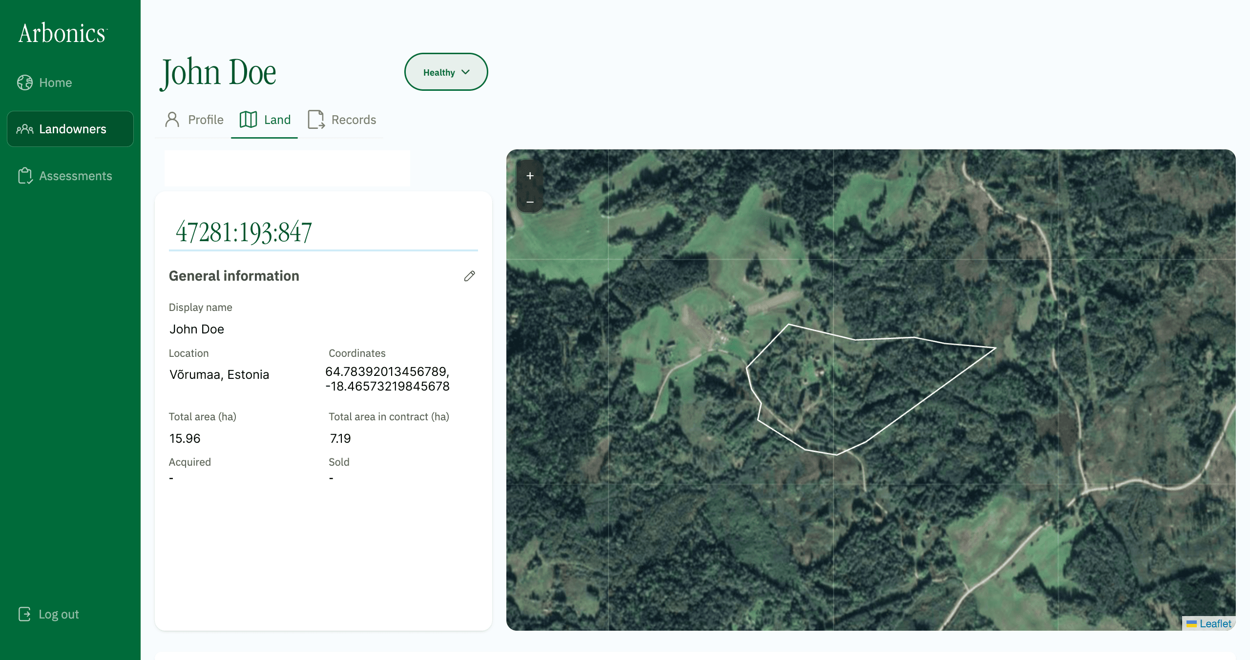 Figure 6: Customer land view in Trunk
Our vision for the future
Our centralised platform was developed to scale and monitor millions of hectares across any number of countries, integrating with any number of different data sources, satellite imagery and remote sensing technologies.
We strive to provide a real-time view and quality score for each of our land plots. This will help us further understand how well forests are sequestering carbon while guiding landowners in understanding how their forests are performing, optimising carbon capture and measuring the impact of changes over time.
Are you a looking to invest in high-impact carbon removal projects? Learn how your organisation can partner with Arbonics by reaching out today.
